
The Ultimate Satellite Data Decision Framework
Aetosky's Guide to Choosing the Right Satellite Data for Mission Success


Introduction

Satellite imagery is the cornerstone of modern geospatial intelligence, offering unparalleled insights into our world. From real-time monitoring of military operations to environmental planning and disaster response, selecting the right type of imagery can significantly influence the success of a mission or project.
Satellite-based technologies broadly fall into three key categories: Passive Optical Sensors, Active Sensors, and Advanced Remote Sensing Systems, each serving unique purposes and providing different insights into Earth's surface and atmosphere. This guide delves into the science behind these technologies and provides a framework for selecting and combining the most suitable data sources for specific operational needs.
1. The Science Behind Satellite Imagery
1.1 Passive Optical Sensors
Passive sensors rely on sunlight reflected off the Earth's surface to capture images. These sensors are ideal for high-resolution, daytime imaging under clear weather conditions.
Multispectral Sensors

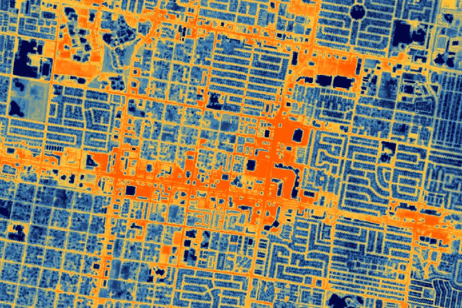
Multispectral sensors capture imagery across a handful of discrete spectral bands, typically including the visible range (Red, Green, Blue) and near-infrared (NIR). Most Earth observation satellites - such as Landsat, Sentinel-2, and commercial satellites like Planet’s Dove and SkySat or Maxar’s WorldView - collect data in multiple spectral bands. It is the most commonly used type of satellite imagery worldwide.
Surveillance and Reconnaissance: Identify infrastructure, troop movements, and vehicle tracking in urban areas.
Urban Mapping and Change Detection: Monitor urban growth, detect illegal construction, and map disaster-prone areas.
Critical Infrastructure Monitoring: Assess road networks, energy grids, and strategic assets.
Vegetation Health in Urban Settings: Monitor green cover and detect tree health for city planning and security operations.
Multispectral imagery provides a balance of spatial and spectral detail, making it useful for near-instant monitoring and broad-area situational awareness.
Hyperspectral Sensors

Hyperspectral sensors tend to collect hundreds of narrow, contiguous spectral bands spanning the visible, near-infrared, and often shortwave infrared regions. This level of spectral detail allows users to detect subtle differences in material composition - far more detailed than the discrete bands found in multispectral systems. Key applications include:
Agriculture: Identifying early signs of crop stress or disease before they’re visible to standard multispectral sensors.
Mineral Exploration: Mapping geological features and locating specific mineral signatures.
Detection of Concealed Objects: Hyperspectral sensors can reveal hidden objects or disturbed earth indicative of underground bunkers or tunnels.
Material Identification for Defense: Detect camouflage materials, distinguish between natural and man-made objects, and assess building composition.
Hyperspectral sensors provide deep spectral insight, crucial for target discrimination, threat detection, and urban security, offering advanced intelligence in complex operational environments.
1.2 Active Sensors
Active sensors emit their energy and measure the reflection from the Earth’s surface, allowing imaging regardless of light or weather conditions.
Synthetic Aperture Radar (SAR)

Uses microwave signals to generate high-resolution images, unaffected by weather or light conditions.
Applications: Ship detection, infrastructure monitoring, and surface change detection.
Advanced SAR Techniques
Polarimetric SAR (PolSAR): Measures different polarizations (e.g., HH, HV, VH, VV) to provide detailed information on surface structure and composition.
Applications: Classifying vegetation types, detecting urban structures, and differentiating between natural and man-made objects.
Interferometric SAR (InSAR): Compares phase differences between multiple SAR images to detect subtle changes in elevation or movement over time.
Applications: Monitoring land subsidence, detecting ice-sheet movement, and assessing structural deformation after earthquakes.
LiDAR (Light Detection and Ranging)

LiDAR uses laser pulses to measure distances, creating highly accurate 3D representations of terrain and structures. It is often used in combination with aerial or satellite platforms.
Applications: Digital terrain modelling, forestry mapping, and infrastructure assessment.
1.3 Advanced Remote Sensing Systems
These emerging technologies combine multiple data sources and cutting-edge techniques for deeper insights and specialised applications.
Thermal Infrared Sensors
Thermal satellite imagery detects heat emissions, allowing for the monitoring of surface temperature, energy consumption, and thermal anomalies.
Applications: Industrial heat mapping, urban heat islands, border surveillance, and strategic site monitoring
Combined Multi-Source Imaging (Data Fusion of Optical, SAR, and LiDAR)
This approach offers unparalleled insights by combining the distinct strengths of each sensor - visual context, structural analysis, and 3D terrain mapping - providing decision-makers with deeper, actionable intelligence.
Applications: Precision agriculture, disaster response, and urban infrastructure monitoring.
2. Technical and Operational Considerations
2.1 Data Resolution and Accuracy
When selecting satellite imagery, understanding the resolution is crucial. Each type of imagery offers different resolutions that affect the precision and suitability for various applications.

Spatial Resolution: Defines the size of the smallest visible object in an image. High-resolution optical imagery provides detail down to sub-metre levels, while SAR can vary depending on the acquisition mode (e.g., Spotlight for high resolution or ScanSAR for wide-area coverage).
Temporal Resolution: Refers to the revisit frequency of the satellite. Optical imagery may offer high temporal resolution but can be compromised by cloud cover, whereas SAR provides consistent data regardless of weather.
Spectral Resolution: Multispectral and hyperspectral sensors offer different levels of spectral detail, which is critical for applications such as vegetation health and mineral exploration.
Radiometric Resolution: Refers to the sensor's ability to detect subtle differences in energy or reflectance levels. It defines the number of intensity levels the sensor can record. Measured in bits, it affects how much detail is captured in terms of brightness or backscatter intensity.
8-bit resolution: 256 intensity levels
12-bit resolution: 4,096 intensity levels
16-bit resolution: 65,536 intensity levels
2.2 Data Processing and Computational Complexity
Each imagery type comes with specific processing challenges.
Multispectral: Requires atmospheric correction and orthorectification to eliminate distortions and ensure spatial accuracy.
Hyperspectral: Generates high-dimensional datasets that demand advanced spectral unmixing and dimensionality reduction techniques. Processing can be computationally intensive.
SAR: Demands advanced processing techniques such as speckle filtering to reduce noise and interferometry (InSAR) for detecting subtle surface changes. SAR processing often involves high computational loads for accurate phase analysis.
LiDAR: Produces dense point cloud data that requires specialised software for terrain modelling and 3D visualisation. Data storage and management can be challenging due to the large volume of data generated.
Thermal: Requires radiometric calibration and temperature correction to ensure accurate surface temperature measurements.

Catalyst Professional/Enterprise (formerly known as PCI Geomatics), is Aetosky’s trusted technology partner and plays a critical role in addressing processing-related challenges. Known for its expertise in SAR and optical imagery processing, Catalyst offers advanced tools for speckle filtering, InSAR analysis, orthorectification, and atmospheric correction.
2.3 Cost and Accessibility
Access to satellite imagery can range from free, open-source datasets (e.g., Sentinel-1, Sentinel-2) to high-cost commercial data (e.g., WorldView, Umbra).
Open-Source Data: Offers excellent temporal and spatial coverage but with limitations in resolution and customisation.
Commercial Data: Provides higher resolution and specialised services at a cost, making it essential for mission-critical applications such as defence and infrastructure monitoring.
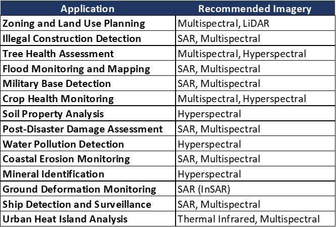
2.4 Use Case Suitability
Different applications require distinct types of imagery. Below is a quick reference guide (non-conclusive and non-exhaustive as organisational requirements vary):
3. Data Selection Framework
Choosing the appropriate satellite imagery depends on various factors, including mission objectives, environmental conditions, and available resources. The following steps offer a structured approach to ensure informed decision-making.
Step 1: Define Mission Objectives
Organisations must clearly articulate what the imagery will be used for. Common objectives include:
Defence and Security Operations: Real-time surveillance, target detection, perimeter security, monitoring troop movements, and identifying underground activities.
Urban Planning and Infrastructure Development: Land use analysis, monitoring urban growth, detecting illegal construction, and assessing critical infrastructure such as transportation networks and utilities.
Environmental and Agricultural Monitoring: Assessing crop health and yield prediction, monitoring soil moisture, mapping deforestation, tracking water resources, and detecting early signs of crop stress or disease.
Disaster Response and Risk Management: Flood mapping, wildfire detection, earthquake damage assessment, and identifying vulnerable areas for proactive planning.
Mining and Resource Exploration: Mapping ore bodies, monitoring slope stability, tracking environmental impact, and identifying mineral compositions using hyperspectral imagery.
Coastal and Marine Monitoring: Ship detection and maritime surveillance, coastal erosion monitoring, and assessing water quality and sediment levels.
Step 2: Match Objectives to Imagery Characteristics
Once the mission objectives are defined, the next step is to align them with the most suitable imagery type. While individual data sources like optical, SAR or multispectral imagery offer unique strengths, data fusion - combining multiple imagery types -provides a more comprehensive and actionable perspective. This approach enhances accuracy, reduces uncertainty, and unlocks deeper insights.
For Continuous Monitoring Despite Weather Conditions: SAR imagery is essential for monitoring in all weather and lighting conditions. Combining SAR with multispectral data enables a more comprehensive view, providing structural detail alongside visual context.
In military surveillance and urban monitoring, SAR can track ground movement and infrastructure stability, while multispectral imagery enhances object identification.
For Ground and Structural Integrity Assessments: LiDAR and SAR (InSAR) are highly effective for monitoring ground deformation and detecting structural changes. Fusing LiDAR's 3D elevation data with InSAR’s surface movement analysis offers deep insights into urban infrastructure and mining operations.
LiDAR can create detailed terrain models of mining sites, while InSAR tracks land subsidence or slope movement.
For Urban Infrastructure and Real-World Representation: High-resolution multispectral imagery delivers natural-colour visuals for easy interpretation. Combined with SAR, it provides a full picture - visual context paired with structural detail.
Multispectral data supports building change detection by identifying alterations in colour or material composition over time, while SAR captures structural deformations and surface movement. This combination allows for comprehensive monitoring of urban development and infrastructure changes.
Step 3: Evaluate Data Availability and Environmental Constraints
Selecting the right satellite imagery requires a thorough assessment of data availability and environmental factors to ensure reliable and actionable insights.
Sensor Availability: Not all sensors have global coverage. Check the operational status and revisit cycle of the satellites you’re relying on.
Archive Imagery Availability: Verify if historical datasets exist for your area of interest. If archive coverage is insufficient, plan for tasking new acquisitions to meet operational requirements.
Cloud Cover Frequency: In regions with persistent cloud cover, optical imagery may be impractical. SAR imagery, with its all-weather capability, ensures consistent data acquisition.
Terrain and Vegetation Density: Dense vegetation and complex terrain can limit the effectiveness of optical data. SAR imagery offers superior penetration and accuracy for monitoring topographic changes and vegetated areas.
Temporal Resolution: Ensure the satellite’s revisit frequency matches your monitoring objectives. High temporal resolution is essential for real-time monitoring and time-sensitive operations.
Environmental Seasonality: Adjust acquisition schedules to account for seasonal changes such as snow cover, flooding, or vegetation growth cycles, which may obscure key features.
Security and Access: Be mindful of data restrictions over sensitive areas, particularly in high-security contexts where high-resolution imagery may be limited.
Cost and Budget: Optimise your budget by leveraging a mix of open-source data for general monitoring and high-resolution commercial data for mission-critical tasks.
Step 4: Consider Computational and Analytical Resources
Evaluate the computational infrastructure available for processing and analysing the chosen imagery.

Cloud-Based Solutions: Ideal for large-scale data analysis with minimal local resource requirements. Cloud platforms offer scalability and the ability to handle large datasets without the need for extensive local hardware.
On-Premise Solutions: Suitable for high-security environments in defence and sensitive government projects. On-premise infrastructure ensures full control over data and processing, reducing external security risks while maintaining compliance with strict data governance policies.
Hybrid: Combine on-premise and cloud infrastructure for optimal flexibility. Sensitive data can be processed locally, while computationally intensive tasks can be offloaded to the cloud. This approach balances security, scalability, and cost-effectiveness, making it ideal for projects with mixed requirements.
Aetosky’s cloud computing and solution architecture experts are uniquely positioned to help organisations design and implement the most suitable computational strategy. With deep experience in scalable infrastructure, high-performance data processing, and secure solutioning, Aetosky ensures clients can achieve maximum operational efficiency without compromising security.
- Thai Bui, Technical Lead
Conclusion
Selecting the right satellite imagery is essential for mission success across defence, urban planning, environmental monitoring, and resource exploration. By leveraging the unique strengths of Passive Optical, Active Sensors like SAR and LiDAR, and Advanced Multi-Source Imaging, organisations can make informed decisions and improve operational outcomes. The combination of these technologies through data fusion and advanced processing frameworks unlocks deeper insights, reduces uncertainty, and enhances situational awareness.
At Aetosky, we don’t just provide access to intelligence software that can harness this data - we offer a comprehensive partnership. Our domain expertise, combined with tailored computational solutions and a deep understanding of real-world operational needs, ensures that our clients are always equipped to meet evolving challenges.
Our team of cloud computing specialists, geospatial analysts, and solution architects work closely with organisations to integrate multi-source data seamlessly, enabling real-time decision-making and long-term strategic planning. Whether it’s building situational awareness for defence operations, enhancing infrastructure monitoring, or driving environmental resilience, Aetosky leads the way in delivering customised, reliable, and future-ready solutions.

In a rapidly changing landscape, Aetosky remains a trusted partner, guiding organisations toward operational excellence through innovative intelligence and decision-making frameworks.
 | A guest post by
|