
Clearer Intelligence, Sharper Decisions
Unlock unmatched detail for precision object detection, urban planning, defense operations, and environmental monitoring


High-quality satellite imagery is indispensable for mission-critical operations and strategic decision-making. From defense and security to environmental monitoring and urban development, organizations rely on precise, up-to-date imagery for actionable intelligence. Yet, raw satellite data often carries noise, atmospheric interference, and resolution limitations.
At Aetosky, we address these challenges head-on. Our AI-driven image enhancement solutions harness deep learning and advanced analytics to deliver exceptional clarity and spectral fidelity. Powered by Generative Adversarial Networks (GANs), Convolutional Neural Networks (CNNs), and cutting-edge Transformer models, our technology transforms raw satellite data into actionable intelligence. This translates to:

Sharper, more detailed images for Precision in object detection, land-use classification, and urban analysis.
Enhanced spectral accuracy for reliable terrain assessment, camouflage detection, and environmental monitoring.
Automated, real-time processing to reduce manual workload and accelerate decision-making
By integrating AI into satellite image processing, organizations significantly boost data value, predictive analytics, and real-time situational awareness. Whether you’re a defense strategist, urban planner, or environmental analyst, embracing Aetosky’s AI-powered enhancements is the key to achieving sustainable impact and operational excellence in today’s rapidly evolving geospatial landscape.
Different types of image enhancement
In remote sensing, image enhancement is critical for extracting actionable insights from satellite data, especially in high-stakes defense and civil operations. Three foundational approaches - Radiometric, Spectral, and Spatial enhancements - ensure every pixel is optimized for clarity and strategic value.
Radiometric Enhancement
What It Does
Modifies brightness and contrast on a per-pixel basis to minimize atmospheric noise. Adjusts brightness and contrast at the pixel level.

Examples
Histogram Equalization: Balances pixel intensity distributions to clarify key features.
Contrast Stretching: Optimizes overall visibility across varied lighting conditions.
Noise Reduction: Removes disruptive grain for cleaner, more interpretable imagery.
Key Impact
Improves operational visibility by refining raw satellite data, enabling faster threat detection in defense scenarios and sharper city infrastructure assessments for urban planners.
Spectral Enhancement
What It Does
Harnesses multiple spectral bands to underscore meaningful patterns invisible in standard RGB images.

Examples
Principal Component Analysis (PCA): Condenses complex data into the most significant spectral components for focused analysis.
Band Ratioing (e.g., NDVI): Highlights vegetation health, land-cover types, or water quality differentials.
Color Composites: Combines bands for enriched visual representation (e.g., true color, false color).
Key Impact
Pinpoints subtle variations vital for both reconnaissance - such as camouflage detection or terrain classification - and urban planning, including environmental impact assessments and resource management.
Spatial Enhancement
What It Does
Exploits neighboring pixels to sharpen edges and heighten structural details.

Examples
High-Pass Filtering (Sharpening): Accentuates critical contours like building footprints or transportation arteries.
Low-Pass Filtering (Smoothing): Eliminates superfluous texture and noise for a clearer macro view.
Edge Detection: Identifies boundaries, aiding in perimeter security and zoning activities.
Key Impact
Delivers razor-sharp clarity of roads, facilities, and other infrastructure, essential for defense surveillance, target identification, and the urban sector’s zoning, infrastructure expansion, and smart city initiatives.
Conventional Methods of Image Enhancement: Where They Fall Short
Before AI-driven advancements, satellite image enhancement relied on traditional techniques like contrast adjustment, noise reduction, and distortion correction. While useful, these methods often struggled with complex datasets, leading to inconsistent clarity, spectral distortion, and limited automation.
Histogram Equalization – Enhances image contrast by redistributing pixel intensity values, making features more distinguishable. However, it may over-enhance noise and lead to loss of subtle details..
Contrast Stretching – Adjusts brightness levels to improve visual clarity but does not restore lost image information or address deeper distortions..
Spatial Filtering – Uses edge detection and noise reduction filters to enhance details yet struggles with balancing clarity and artifact suppression.
Fourier Transform Processing – Removes periodic noise and enhances image structure but requires extensive manual fine-tuning and computational effort.
Pan-Sharpening – Fuses high-resolution panchromatic images with lower-resolution multispectral images to enhance spatial detail, though it can sometimes distort spectral fidelity.
While these methods have been foundational in remote sensing, they often require manual adjustments, lack adaptability to varying conditions, and cannot effectively reconstruct missing or obscured data. This is where AI-powered technologies take enhancement to the next level—offering automated, data-driven solutions that learn, adapt, and deliver superior results with minimal intervention.
Challenges of Satellite Image Resolution: Why AI-Powered Enhancement is Essential
Despite advancements, satellite imagery still faces key challenges: poor resolution, high costs for high-resolution data, and limited automation. While free datasets (Sentinel, Landsat, MODIS) offer accessibility, they lack fine detail. High-resolution imagery from providers like DigitalGlobe, Planet, and SkySat remains expensive and restricted.
Key Limitations of Satellite Image Data
Expensive High-Resolution Data: Commercial high-resolution images (e.g., from Digital Globe, Planet, and others) are expensive, limiting accessibility for large-scale and long-term projects.
Limited Coverage & Accessibility: Commercial satellite operators may have limited coverage or predefined areas of interest, meaning the required image may not be available for every geographic location or time period.
Atmospheric Interference & Data Quality Issues: Cloud cover, haze, sensor noise, and radiometric inconsistencies reduce image clarity, often requiring extensive preprocessing.
Limitations of Low-Resolution Data: While free satellite imagery (e.g., Sentinel-2, Landsat-8, MODIS) is widely available, low-resolution images come with their own set of challenges:
Limited Detail and Precision: Poor resolution means fewer pixels per area, reducing the ability to identify small objects and landscape features.
Inaccurate Feature Detection: Low-resolution images struggle with object detection, misclassifying buildings, crops, or land-cover types.
Challenges in AI and Automated Mapping: Machine Learning (ML) and AI models perform poorly with low-resolution data due to a lack of fine details needed for accurate predictions.
Why AI-Powered Image Enhancement is the Future
AI-driven Super-Resolution Models, Deep Learning-Based Denoising, and Generative Enhancement Techniques are reshaping how satellite images are processed. By leveraging AI, geospatial professionals can:
Enhance Low-Resolution Images – AI models like CNNs and GANs reconstruct finer details, making even medium-resolution imagery highly usable.
Reduce Dependence on Costly High-Resolution Data – AI-enhanced images bridge the quality gap, providing near-high-resolution outputs from lower-cost datasets.
Automate Noise Reduction & Cloud Removal – AI-powered atmospheric correction algorithms ensure clearer, distortion-free imagery, reducing the need for manual intervention.
Optimize Large-Scale Image Processing – AI automates enhancement workflows, significantly improving efficiency and scalability for industries like urban planning, forestry, and climate monitoring.
Super-Resolution: Enhancing Satellite Imagery with AI
Super-Resolution (SR) is an advanced image processing technique that enhances the resolution of low-quality images by reconstructing finer details and improving clarity. In the field of satellite imagery and remote sensing, SR is critical for extracting meaningful insights from low-resolution data, enabling applications such as urban planning, environmental monitoring, precision agriculture, and disaster response. Traditional image upscaling methods, such as bicubic interpolation, often result in blurry and unrealistic images. In contrast, AI-powered Super-Resolution techniques, particularly Deep Learning (DL) models like Generative Adversarial Networks (GANs) and Convolutional Neural Networks (CNNs), learn complex spatial and spectral patterns to produce high-resolution images with sharper details and minimal artifacts.

Earlier Methods of Super-Resolution
Before the rise of AI-driven approaches, Super-Resolution was achieved through manual and statistical methods, which were computationally expensive and required expert intervention. These conventional techniques were broadly categorized into two types:
1. Single-Image Super-Resolution (SISR)
This method enhances the resolution of a single low-resolution image. However, due to the lack of additional data, reconstructing fine details was difficult. Common approaches included:
Interpolation-based methods – Bicubic, bilinear, and nearest-neighbor upscaling, which introduced blurring and loss of detail.
Reconstruction-based methods – Regularization and edge-preserving algorithms that required prior knowledge of image structure.
Learning-based methods – Early machine learning models that used pixel-wise learning but struggled with complex textures.
2. Multi-Image Super-Resolution (MISR)
This approach leveraged multiple low-resolution images of the same scene taken at different times or angles to reconstruct a high-resolution image.
Frame fusion techniques combined overlapping pixel information to enhance resolution.
Patch-based approaches used statistical modeling to predict missing details.
Sparse coding and dictionary learning attempted to map low-resolution patches to high-resolution structures.
Current Advancements: Super-Resolution
The advent of Deep Learning (DL) and AI-driven Super-Resolution models has revolutionized satellite image processing by automating resolution enhancement and improving feature reconstruction.
Convolutional Neural Networks (CNNs)
Extract spatial features from images and enhance details using multi-layer transformations.
Example: SRCNN (Super-Resolution Convolutional Neural Network), one of the first deep learning-based SR models.
Generative Adversarial Networks (GANs)
AI-generated high-resolution images from low-resolution inputs by training a generator and discriminator network in competition.
Example: SRGAN (Super-Resolution GAN), which produces realistic textures and sharp edges.
Transformer-Based Models
Capture long-range dependencies in images, allowing for more context-aware Super-Resolution.
Example: SwinIR (Image Restoration Transformer), known for its ability to enhance fine details while preserving spectral accuracy.
The Working Mechanism of Super-Resolution
The process begins with Step 1: Preprocessing & Input Handling, where a low-resolution satellite image is taken as input, normalized, and resized. The AI model then identifies key features such as edges, textures, and spectral patterns to prepare the image for enhancement. Next, in Step 2: Feature Extraction, deep learning models analyze the image using CNNs to extract spatial features, GANs to refine textures and edges, and Transformers to capture long-range dependencies for more accurate upscaling. In Step 3: Super-Resolution Image Reconstruction, the AI model reconstructs missing high-resolution details, enhances textures, improves contrast, and ensures spectral consistency for precise geospatial analysis. Finally, Step 4: Post-Processing & Output Generation focuses on denoising, sharpening, and artifact removal to maximize clarity.

Benefits of AI-Powered Super-Resolution Compared to Conventional Methods
AI-powered Super-Resolution (SR) offers significant advantages over traditional satellite image enhancement techniques by automating resolution improvement, preserving finer details, and delivering high-quality results with minimal artifacts.

Aetosky’s Role in AI-Powered Super-Resolution
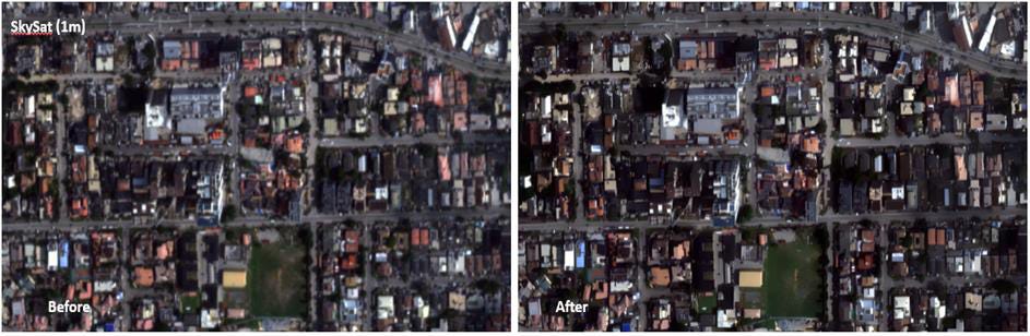
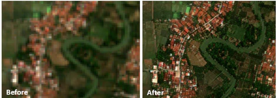
Aetosky is at the forefront of AI-driven Super-Resolution (SR) technology, offering cutting-edge solutions for enhancing satellite imagery. Our advanced AI-powered SR models are specifically designed to enhance Sentinel-2 imagery (10 m) and multi-resolution satellite data (ranging from 0.5m to 3m resolution), providing users with unparalleled clarity and precision for geospatial applications.
Technical Specification

Key Features of Aetosky’s Super-Resolution Technology
Custom AI Models for Sentinel-2 – Tailored Super-Resolution models optimized for enhancing free Sentinel-2 imagery, making it comparable to high-resolution commercial datasets.
Multi-Resolution Super-Resolution (0.5m to 3m) – Supports a wide range of satellite images, allowing users to upgrade lower-resolution data for better insights.
2x and 4x Image Enhancement – Enables users to double or quadruple image resolution, providing sharper textures, clearer object boundaries, and improved spectral accuracy.
Automated AI Processing – Eliminates the need for manual image enhancements, delivering fast and reliable high-resolution outputs.
Preserves Spectral Integrity – Ensures that important spectral information remains accurate, which is crucial for vegetation indices, water quality assessments, and land-use classification.
How Aetosky’s SR Technology Benefits Users
Urban Planning & Infrastructure – Provides high-resolution city mapping for better zoning, transportation, and infrastructure management.
Land use and land cover mapping: AI-enhanced imagery allows for more detailed and accurate mapping of land use and land cover, which is crucial for environmental monitoring, urban planning, and resource management.
Precision agriculture: Improves farm boundary detection, enhances crop classification, and enables early crop health assessment, ensuring precise land management and better yield estimation.

Object detection: Enhances object detection, improving the identification of ships, airplanes, tree counts, and other critical features with greater accuracy and clarity.

Conclusion
AI-powered Super-Resolution (SR) is revolutionizing satellite image enhancement by overcoming the limitations of traditional methods. Conventional techniques struggle with resolution loss, spectral distortions, and manual adjustments, whereas AI-driven SR leverages deep learning models (CNNs, GANs, and Transformers) to reconstruct fine details, improve clarity, and maintain spectral integrity.
The impact of AI-powered SR spans various sectors. In urban planning, it enhances infrastructure mapping and land-use classification. In environmental monitoring, it improves tracking of deforestation, water resources, and climate change. Agriculture benefits from better crop monitoring and irrigation planning, while disaster management sees improved damage assessment. In defense, SR aids in military surveillance, reconnaissance, and border security, allowing precise detection of aircraft, ships, and ground vehicles.

Aetosky leads in AI-powered Super-Resolution, offering Sentinel-2 and multi-resolution enhancements (0.5m–3m) with 2x and 4x upscaling. By making high-resolution geospatial intelligence more accessible and cost-effective, Aetosky empowers industries with automated, high-precision satellite image enhancement.
 |
|