
DEM Data (Digital Elevation Models) Is a Game Changer - Have You Unlocked Its Power?
Gain the tactical edge with real-time terrain intelligence - integrating DEM data with AI for smarter, faster defense decisions


What Is DEM Data?

A Digital Elevation Model (DEM) is a precise, raster-based representation of the Earth's terrain, where each grid cell encodes elevation data relative to a vertical reference point, or datum. This zero-elevation surface standardizes height measurements, delivering consistency essential for geospatial analysis in defense and government operations. Trusted by geoscientists, insurers, and surveyors alike, DEMs ensure accuracy and reliability when modeling complex terrains.

DEM resolution determines terrain insight granularity. High-resolution models with smaller grid cells capture subtle elevation changes, essential for mission-critical tasks like flood modeling and landscape assessment. Lower-resolution models (around 20 meters or more) provide generalized terrain views suited for broad-scale analysis.
DEMs are built from diverse remote sensing sources - satellites, drones, and aircraft - ensuring comprehensive coverage, even in remote areas. Advanced methods like stereo satellite imagery extraction deliver precise elevation data, as seen with SPOT-5 sensors offering 5 to 10-meter resolution. This accuracy empowers defense organizations with fast, data-driven decision-making.

Several remote sensing methods are commonly used to produce DEM surfaces:
1. Synthetic Aperture Radar Interferometry (InSAR)
Synthetic Aperture Radar Interferometry (InSAR) is a powerful technique that generates high-precision elevation models by combining radar data from multiple antennas captured almost simultaneously. One of the most significant applications of InSAR is the Shuttle Radar Topography Mission (SRTM), which successfully created global DEMs, setting the benchmark for large-scale terrain mapping. To minimize urban artifacts and improve data accuracy, modern approaches now integrate deep learning techniques, as demonstrated by CoastalDEM.

2. Stereo Photogrammetry
Stereo photogrammetry generates precise Digital Elevation Models (DEMs) by analysing overlapping high-resolution images from slightly different angles, mimicking human binocular vision. This technique creates dense point clouds and continuous raster grids, delivering fine-scale DEMs without extensive ground measurements.

3. Light Detection and Ranging (LiDAR)
LiDAR is a cutting-edge remote sensing technology that generates highly accurate Digital Elevation Models (DEMs) by emitting laser pulses towards the ground and measuring their return time. Mounted on aircraft, drones, or satellites, LiDAR rapidly captures vast elevation data, even in dense vegetation or hard-to-reach areas. Advanced processing filters out non-ground features to create bare-earth DEMs with centimetre-level accuracy. For defense, LiDAR-generated DEMs are invaluable for terrain analysis, infrastructure mapping, line-of-sight assessments, and mission planning - delivering unmatched precision for high-stakes operations.

4. Contour Line Digitisation
Contour line digitisation converts topographic maps into Digital Elevation Models (DEMs) by tracing contour lines using GIS software. Interpolation then generates a continuous surface model. While less precise than LiDAR or stereo photogrammetry, it remains valuable when remote sensing data is limited or historical maps are needed. In defense, contour line digitisation supports terrain visualisation, strategic planning, and route analysis - delivering essential situational awareness when high-resolution DEMs are unavailable.

5. Ground Surveying
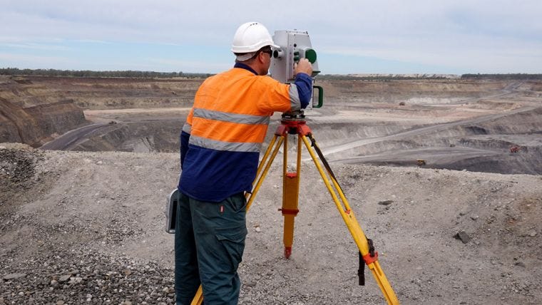
Ground surveying remains fundamental in generating Digital Elevation Models (DEMs), capturing elevation data directly from the Earth's surface using advanced ground-based instruments like total stations, GPS receivers, and leveling devices. By establishing a network of control points, surveyors obtain precise topographic measurements, forming a continuous raster surface through data interpolation. Although more time-consuming compared to remote sensing techniques, ground surveying ensures unparalleled accuracy- essential for military installations, critical infrastructure development, and terrain validation. In defense applications, ground-surveyed DEMs are indispensable for engineering projects, mission planning, and site analysis, ensuring that every elevation point is precisely mapped and reliable.
Digital Elevation Data For The Defense Industry
Digital Elevation Models (DEMs) are mission-critical for defense, providing precise terrain intelligence through advanced remote sensing. These raster-based datasets deliver accurate elevation insights essential for planning, analysis, and operational readiness.
Leveraging AW3D For The Defense Industry
Accurate geospatial data is crucial for mission success in defense. Advanced World 3D (AW3D), developed by NTT Data and RESTEC, sets the benchmark for high-resolution, global terrain intelligence. With resolutions as fine as 0.5 metres, AW3D delivers consistent, precise elevation data worldwide, ensuring unmatched accuracy for mission-critical applications.
Derived from high-resolution satellite imagery, AW3D undergoes rigorous processing to eliminate noise and enhance accuracy, maintaining its status as one of the most reliable elevation data sources on the market. Defense organisations rely on AW3D for confident planning, precise operations, and superior strategic outcomes - where precision is non-negotiable.

Applications Of AW3D In The Defense Industry
1. Enhancing Terrain Analysis
Terrain analysis is essential for mission success. AW3D’s high-resolution DEM data enables defense teams to create detailed 3D terrain models, delivering precise line-of-sight (LOS) assessments for surveillance and targeting. By analysing elevation profiles and slope angles, planners identify optimal vantage points and obstacles, enhancing mobility analysis and route planning to minimise threats and maximise efficiency.
2. Precision in Mission Planning
Precision is vital in mission planning, and AW3D delivers the geospatial accuracy needed for confident, data-driven decisions. Its topographic data supports optimal equipment placement - whether deploying radar, communications, or conducting LOS analysis - ensuring maximum coverage and signal strength.
In fast-paced environments, AW3D accelerates rapid response by identifying flat areas for helicopter landing zones (HLZ) and airdrop points, eliminating guesswork and streamlining decision-making. Defense teams can position assets strategically and operate with precision and confidence.
3. Intelligence Gathering and Surveillance
Intelligence gathering demands accurate, real-time terrain insights. AW3D’s integration with SAR and LiDAR systems delivers high-resolution DEMs, revealing subtle terrain changes and structural features critical for threat detection and situational awareness.
Combining AW3D elevation data with thermal or multispectral imagery provides a multi-dimensional view, identifying camouflaged installations and monitoring terrain shifts. This data fusion empowers defense organisations with actionable intelligence for faster, more informed decisions.
Integration Of DEM Data With Aetos AI
1. Data Fusion and Processing
Combining high-resolution DEMs with satellite imagery, LiDAR data, and other geospatial inputs, Aetos AI enables rapid analysis of vast and complex datasets with unmatched efficiency and accuracy. This integration transforms terrain data into actionable intelligence, automating terrain analysis, feature extraction, and change detection to deliver real-time insights into evolving landscapes and emerging threats.
Through data fusion, Aetos AI correlates elevation data with contextual information- such as vegetation cover or infrastructure layouts- enhancing situational awareness and operational planning. By predicting terrain-based risks, optimizing route planning, and evaluating line-of-sight scenarios, our platform significantly reduces manual data interpretation time while delivering high-confidence results. This AI-powered approach not only empowers decision-makers with precise, actionable intelligence but also revolutionizes defense operations in dynamic and challenging environments.
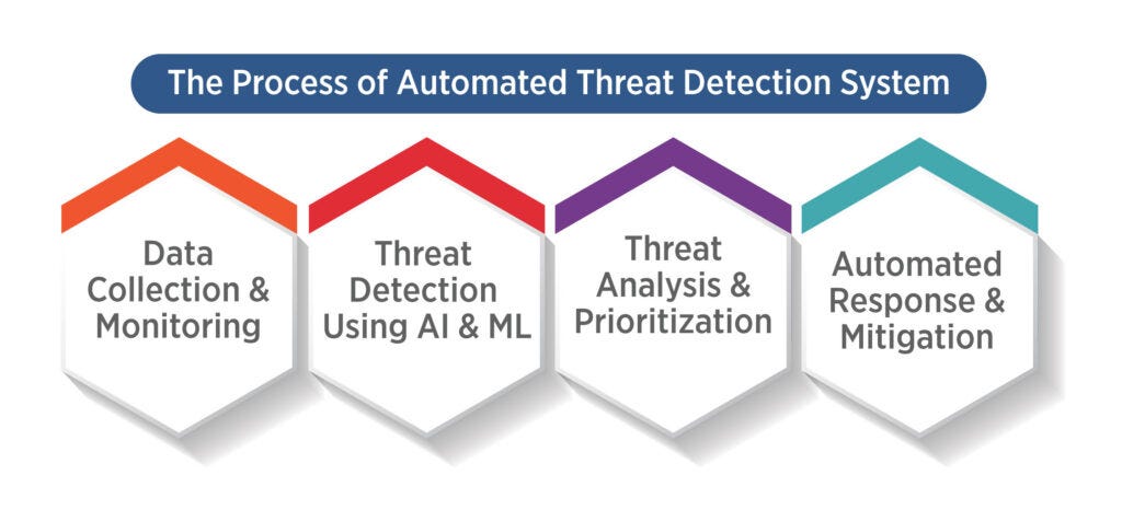
2. Automated Threat Detection & Predictive Terrain Analytics
Aetos AI leverages AW3D data to detect anomalies, movement patterns, or terrain changes that may indicate potential threats or enemy activities. Through automated threat detection, military personnel receive timely alerts, enabling proactive responses to emerging risks. Powered by machine learning, our platform predicts the impact of terrain on troop movements, vehicle navigation, and line-of-sight calculations, optimizing strategic planning and tactical execution.
Predictive models also forecast terrain changes over time, providing invaluable insights for long-term operational planning. By anticipating how terrain dynamics might affect mobility and line-of-sight, defense organizations stay ahead of potential challenges, maintaining a decisive tactical advantage.
3. Real-Time Situational Awareness Through Advanced Change Detection Systems
Aetos AI’s advanced change detection systems automatically process vast volumes of satellite imagery and airborne sensor data, detecting subtle changes in terrain, vegetation, urban development, and land use in near real-time. These insights are crucial for monitoring dynamic environments, including identifying deforestation, floodplain shifts, or construction impacts, all with exceptional speed and precision.
By automating change detection, Aetos AI improves monitoring efficiency and enhances the ability to predict and respond to emerging issues. Defense and government organizations benefit from scalable, adaptable remote sensing systems that manage complex, ever-changing environments with accuracy and reliability. This integration not only supports proactive management but also drives more informed, data-driven decision-making processes, safeguarding mission success in the most challenging conditions.
Real-Life Case Study Of DEM Use In The Military Sector
Digital Elevation Models (DEMs) have proven indispensable in a range of military and defense applications, delivering mission-critical insights that enhance operational effectiveness and situational awareness. Here are some real-life case studies demonstrating the transformative impact of DEM technology:
Enhanced Passability Maps Through DEM Generalization
Innovative methodologies have been developed to generalise DEMs for creating military passability maps, optimizing terrain assessment for mobility and route planning. By analyzing key terrain features- such as slopes, obstacles, and surface characteristics- these generalized DEMs help evaluate the passability of military vehicles and personnel, directly supporting mission execution and risk mitigation.
One notable application involves using DEMs to generate passability maps for desert environments, where accurate terrain analysis is essential for safe and efficient movement. The detailed elevation data supports line-of-sight calculations, identification of strategic vantage points, and optimal route selection- all critical for mission planning and execution in harsh, unforgiving landscapes.
By leveraging DEM-based passability analysis, defense organizations enhance operational efficiency and reduce the risks associated with navigating challenging terrains.

Challenges And Future Prospects Of DEM
While the benefits of DEM data in defense applications are undeniable, challenges remain - particularly regarding data accuracy in urban or densely vegetated environments. Surface features can distort elevation measurements, making it crucial to employ advanced techniques like InSAR and LiDAR to minimize errors. Ongoing research continues to enhance data precision, focusing on integrating machine learning algorithms for automated terrain analysis and utilizing high-frequency satellite updates for real-time monitoring.

As remote sensing technology evolves, the defense sector will continue to develop more sophisticated methods for generating and leveraging DEM data. The goal is to maintain operational superiority through enhanced situational awareness and data-driven decision-making, paving the way for even greater strategic impact.
 |
|