
Why “Analysis-Ready Data” Is Now Mission-Critical for Government Agencies
ARD-First Operations: Faster, Sharper Insight


Latency is the enemy of insight. Whether you are directing wildfire crews, calibrating a new satellite sensor, or cueing an ISR platform, the value of Earth-observation pixels decays in hours - yet most organisations still spend weeks converting Level-1 scenes into something they can actually use.

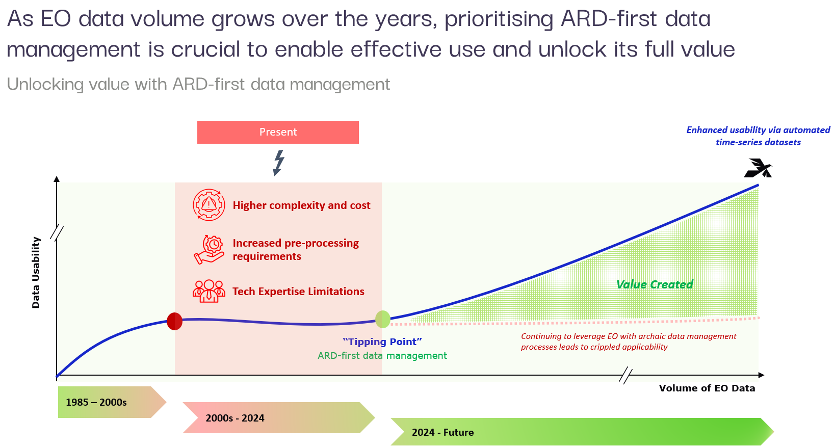
Adopting an ARD-first posture collapses that gap. It replaces artisanal, sensor-specific workflows with a single, automated supply chain that serves civil government portals, space-agency science archives, and defence fusion cells from the same authoritative data cube. The result is a shared, trusted picture of the Earth that all agencies can exploit without re-inventing preprocessing.
Agencies that migrate to an ARD-first posture unlock three strategic advantages:
Near-real-time insight - From downlink to operational map in under 48 hours, even at national scale.
Force-multiplied analysts - 15× throughput because specialists interrogate patterns, not wrangle files.
Single source of truth - Every pixel, every model inference, fully traceable and audit-ready.
Over the last five years we have deployed these pipelines for defence ministries, land authorities, and smart-city programmes across Asia and the Middle East - proving that ARD is bullet-proof at petabyte scale and agile enough for forward-edge operations.
1. What exactly is ARD?
Analysis Ready Data (ARD) refers to satellite imagery that has undergone multiple preprocessing steps to ensure it's immediately usable for analysis - without requiring extensive data cleaning or correction.
The Committee on Earth Observation Satellites (CEOS) defines ARD as data that have been radiometrically, atmospherically, and geometrically corrected, packaged with complete metadata, and tiled on a consistent grid so they can be analysed immediately with minimal user-side preprocessing.
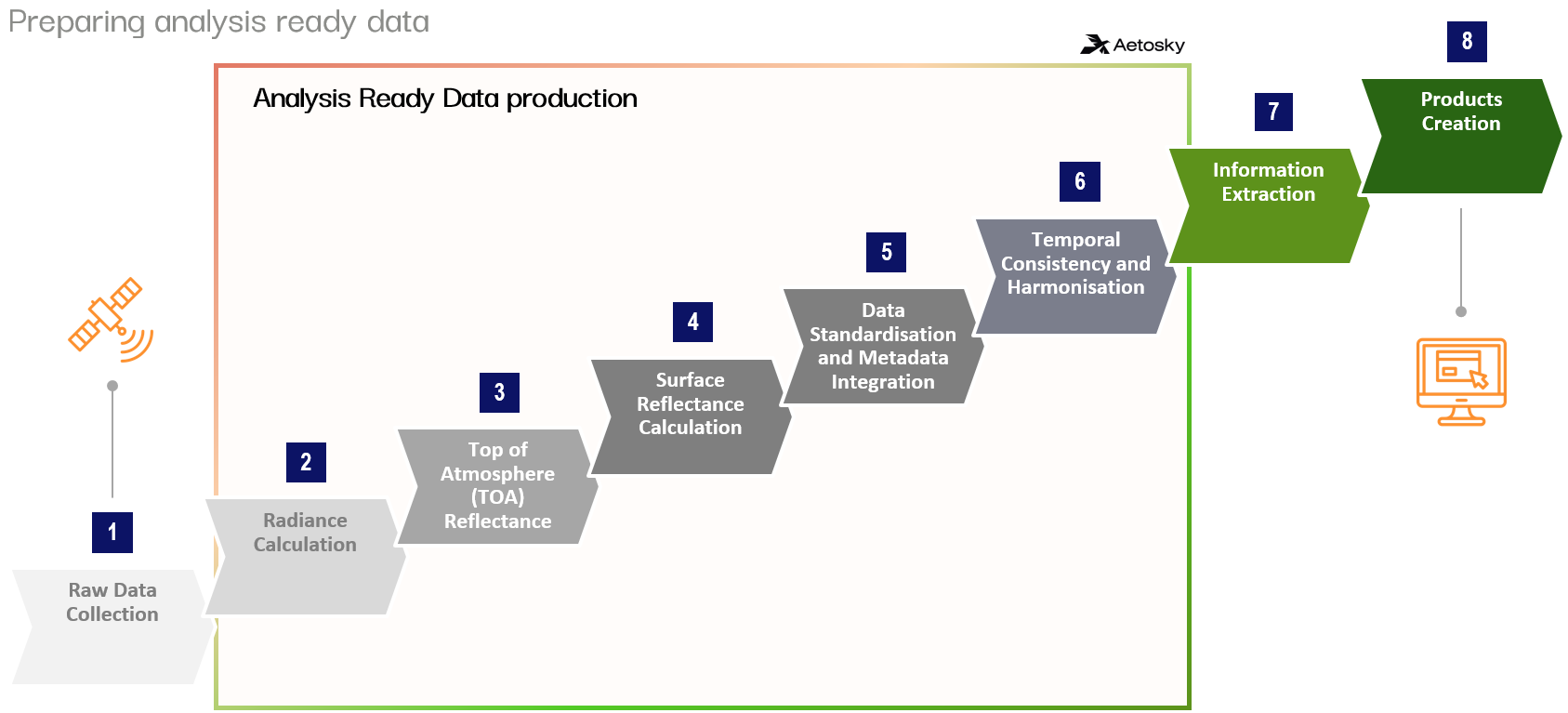
Four Processing Tiers That Turn “Images” into “Information”
After these four stages, the imagery is “Analysis-Ready Data.” Civil planners, space-agency scientists, and defence analysts all start from the same, trusted baseline - no extra scripts, no second-guessing the pixels.
2. The Hidden Cost of Manual Pipelines (and Why They Fail at Scale)
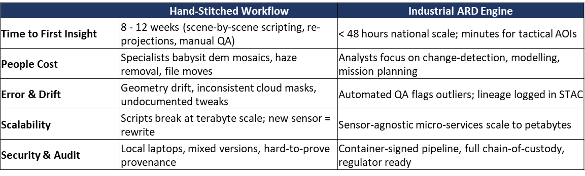
The diagram you saw earlier is not “workflow hygiene”; it is institutionalised latency. Each discrete step feels manageable, yet together they form a slow, fragile conveyor-belt that starves operations of timely data.
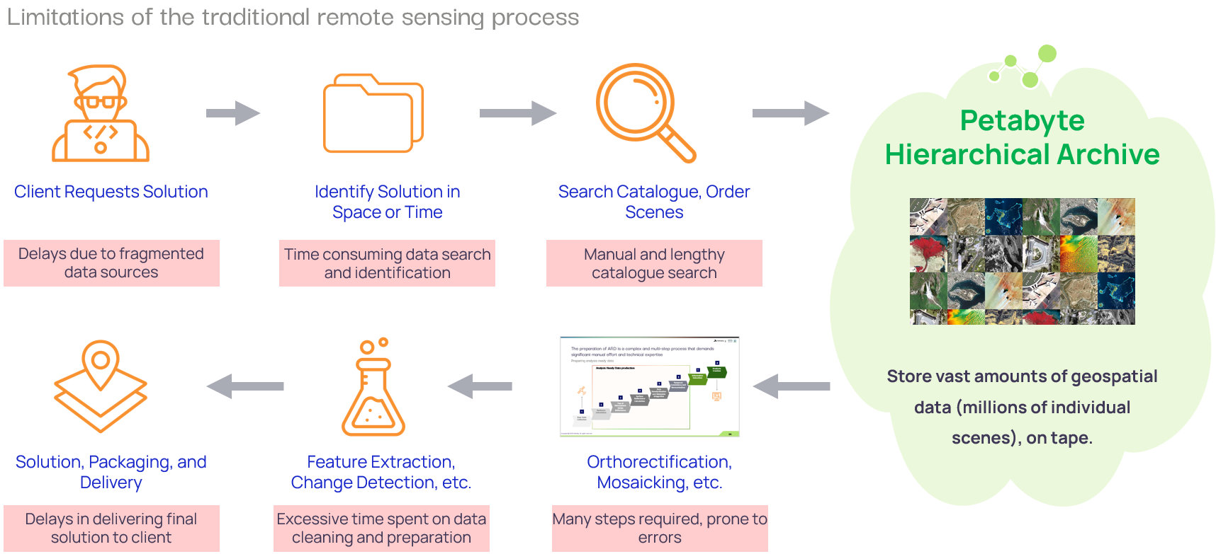
Every pink call-out in the diagram above marks a latency amplifier or error gateway. The accumulation of manual hand-offs - from fragmented search through tape retrieval and scene-by-scene correction - turns what should be near-real-time intelligence into a weeks-long slog. This is exactly the bottleneck that a fully automated Analysis Ready Data (ARD) pipeline eliminates: one ingestion, one correction, infinite re-use.
Net Result: Typical ministries report 8-12 weeks from scene acquisition to first usable layer; 60 % of analyst salaries are subsidising data janitorial work.
3. Automate Once, Re-use Forever
By contrast, an industrial-grade ARD pipeline - built on Aetosky’s specifications and STAC-enabled catalogs - automates these repetitive steps once and exposes clean, analysis-ready pixels to every downstream model and map.
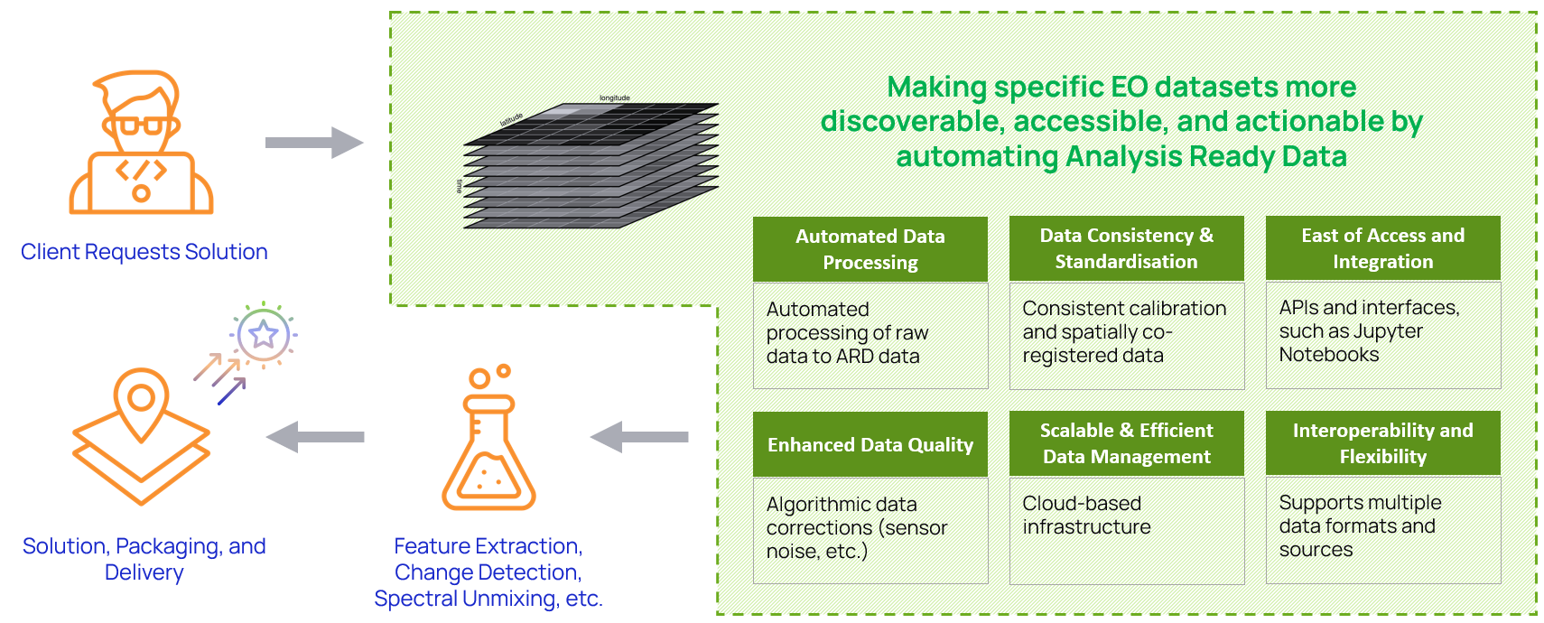
That is the architecture we have deployed for national mapping agencies, smart-city programmes, and energy majors across government agencies in Asia and the Middle East. The result:
95 % reduction in time from acquisition to first insight
15× analyst throughput with identical headcount
Full audit trail for regulators, financiers, and mission partners
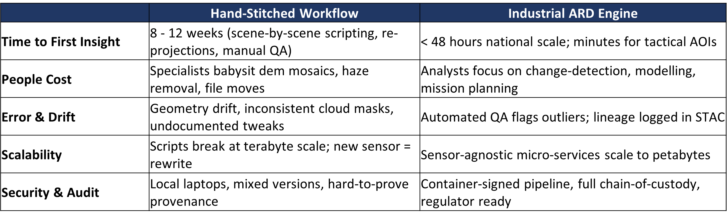
4. Manual vs Automated: The Reality Check
Defence & Strategic Agencies:

With imagery delivered pre-corrected and perfectly co-registered, analysts can stack daily scenes into a clean time-series cube and automatically surface high-value events: newly parked aircraft on remote airstrips, unusual vessel patterns that hint at shadow fleets, or incremental fortifications along border roads and fences. Instead of quarterly manual reviews, decision-makers get a live, evidence-based picture of air, sea, and frontier activity - ready to cue patrols, sanction lists, or diplomatic briefs while the window for action is still open.
National Space & Remote-Sensing Agencies:

An automated ARD backbone lets an agency spin raw down-links into sellable surface-reflectance, land-cover, or urban-growth layers at the push of a recipe. Because every product is spectrally harmonised and metadata-rich, it can be licensed to regional ministries, insurers, or engineering firms with confidence in its accuracy and provenance - opening new revenue streams while cementing the agency’s role as the authoritative data provider for its region.
Civil Governments & Disaster-Response Authorities:

When a cyclone, landslide, or bridge collapse triggers an urgent request, operations teams no longer wait a week for bespoke preprocessing. Cloud-free, geometrically locked tiles flow straight into web dashboards within a day, enabling rapid flood-extent mapping, road-network status checks, and damage estimates that guide where to send engineers, first responders, and relief funds.
5. Turning Pixels into Shared, Actionable Knowledge
An ARD-first posture is more than an efficiency upgrade; it is the foundation for a shared, always-current view of the planet that defence planners, national space programmes, and civil-government responders can act on without re-inventing the data plumbing each time a new requirement lands. By automating the radiometric, atmospheric, geometric, and packaging tiers once, agencies transform raw Level-1 scenes into a harmonised time-series cube that:
Shrinks latency from weeks to hours, aligning decision cycles with on-the-ground realities.
Liberates talent, shifting specialists from file wrangling to mission analysis and innovation.
Delivers one source of truth, where every pixel, correction, and model inference is traceable and audit-ready.


Whether the goal is live aircraft and vessel detection, monetisable data layers for regional partners, or rapid disaster-impact mapping, an industrial ARD backbone ensures that each stakeholder starts from the same clean slate of imagery - ready for insight, not re-processing. In short: process once, exploit everywhere, and let timely, trustworthy data drive the next generation of Earth-observation missions and public-sector decisions.