Multi-Domain ISR: Leveraging Satellite, Radar, and Signal Technologies for Strategic Superiority
Leveraging Advanced Satellite Imaging and Analytics to Transform Strategic Decision-Making and Global Security Operations
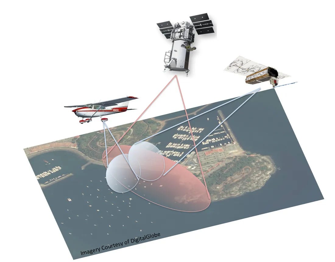
In the evolving landscape of global security, intelligence superiority is no longer defined by a single platform or domain. Modern conflicts and strategic operations increasingly rely on a layered, multi-domain approach to Intelligence, Surveillance, and Reconnaissance (ISR), combining space-based assets with advanced airborne and electromagnetic sensors. From high-resolution satellite imagery to real-time radar signals and signals intelligence (SIGINT) collected by unmanned aerial systems, the fusion of these technologies delivers a comprehensive, persistent, and adaptive intelligence network. As governments invest heavily in satellite constellations, synthetic aperture radar (SAR), hyperspectral imaging, and airborne ISR platforms, the integration of sovereign AI becomes the key enabler - transforming raw data into actionable intelligence at unprecedented speed and scale.
The Strategic Shift to Space
The traditional domains of warfare - land, sea, and air have been fundamentally reshaped by the advent of space-based systems. Intelligence, Surveillance, and Reconnaissance (ISR) platforms in space are not limited by borders, terrain, or weather. Satellites orbit the Earth in predictable patterns, providing persistent surveillance across vast and contested territories without the risk of being intercepted.
As geopolitical tensions rise and battlespaces become more complex, the value of space-based ISR capabilities has skyrocketed. From early warning systems to battlefield management, satellite intelligence allows decision-makers to act faster, with greater precision and confidence.
The Strategic Role of Satellite-Based ISR
Space-based intelligence, surveillance, and reconnaissance (ISR) provides a constant and comprehensive view of Earth’s surface. Satellites can cover denied or contested areas, penetrate adverse weather conditions, and operate without risking personnel. This persistent ISR allows military leaders to:
Detect troop build-ups and infrastructure development.
Monitor missile sites and nuclear facilities.
Observe maritime movements and illicit trafficking.
Support targeting with precision location data.
But raw imagery alone is not enough. The real power lies in the diversity of imaging technologies and the analytics tools used to interpret them.
Hyperspectral Imagery: Spectral Fingerprints From Space
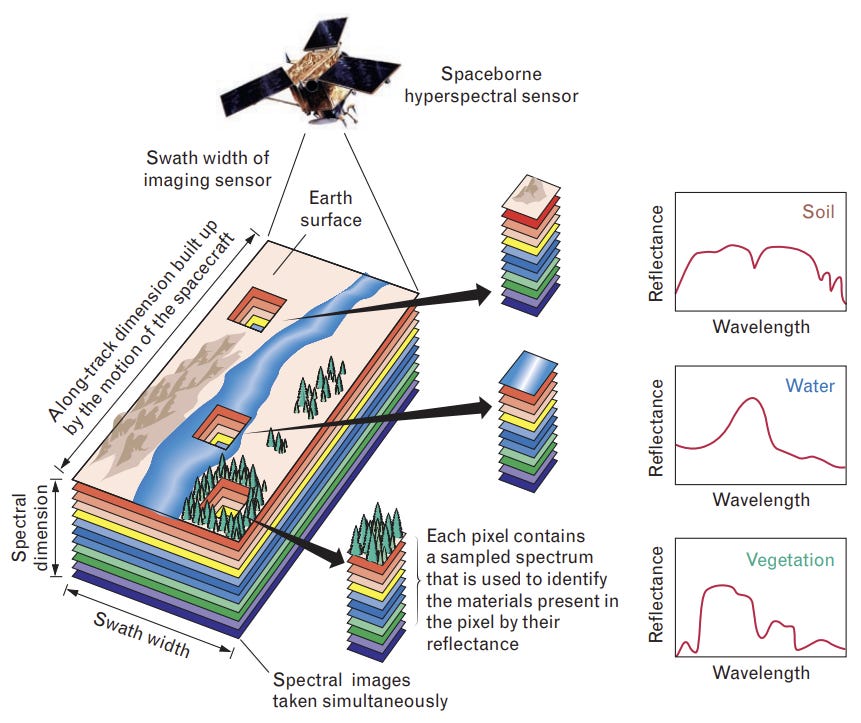
Hyperspectral imaging (HSI) collects data across hundreds of narrow, contiguous spectral bands. Each material on Earth reflects light uniquely, creating a distinct spectral signature. By analyzing this data, military analysts can identify objects and materials that are invisible in traditional imagery.
Key Applications of Hyperspectral Imaging:
Camouflage Detection: HSI can distinguish between natural vegetation and artificial materials used in concealment.
Chemical and Explosive Detection: Identifies residue and materials associated with chemical weapons or IEDs.
Underground Infrastructure Analysis: Subtle differences in vegetation or soil health above buried structures (like tunnels or bunkers) can be detected.
Environmental Monitoring: Critical for understanding terrain suitability and operational risks in hostile environments.
HSI is especially powerful when fused with other imagery types, allowing multi-layered intelligence products.
Multispectral Imagery: Operational Awareness Across The Spectrum
Multispectral imaging (MSI) captures data across a smaller number of broader spectral bands - usually spanning visible, near-infrared (NIR), and shortwave infrared (SWIR). Though less detailed than HSI, MSI is valuable for large-scale monitoring and faster data collection.
Key Applications of Multispectral Imaging:
Night and Low-Light Surveillance: Near-infrared imaging enables night-time reconnaissance.
Vegetation and Ground Cover Analysis: Useful for determining movement through terrain, assessing ground traffic patterns, or spotting recently disturbed soil.
Thermal Tracking: MSI can detect heat signatures, enabling tracking of vehicles or personnel.
Disaster Response and Damage Assessment: MSI supports rapid damage analysis in post-strike assessments or humanitarian missions.
MSI provides a balance between coverage and detail, making it ideal for tactical operations and wide-area surveillance.
Synthetic Aperture Radar (SAR): All Weather Day-Night Imaging
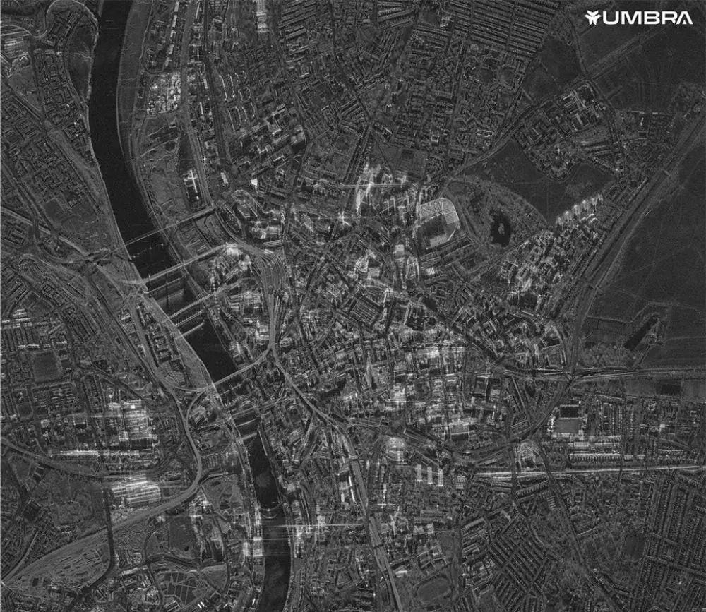
SAR imaging uses radar pulses to generate high-resolution images of Earth’s surface, regardless of weather or lighting. Unlike optical systems, SAR can see through clouds, smoke, and darkness. This makes SAR data indispensable for 24/7 surveillance and reconnaissance.
Key Applications of SAR:
Change Detection: SAR excels in identifying subtle changes over time, such as vehicle movement, new construction, or terrain alterations.
Infrastructure Monitoring: Detects damage to runways, bridges, or railways
Maritime Surveillance: Tracks ships even in rough seas or under cloud cover. Critical for anti-piracy, smuggling interdiction, and naval operations.
Battle Damage Assessment (BDA): After an airstrike or artillery operation, SAR can confirm hits and evaluate impact quickly.
Advanced SAR systems also support interferometry (InSAR), which can detect ground deformation to millimeter precision. This serves as a potential early warning for underground military activity.
What Are Some Other Emerging Imagery Technologies?
1. Advanced Thermal Infrared Imaging
Thermal sensors detect heat emissions and can visualize temperature differences on the ground. They’re invaluable for:
Monitoring vehicle engine heat or troop movements at night.
Detecting fires, missile launches, or explosions.
Surveilling urban areas where energy usage can reveal activity

2. LiDAR (Light Detection and Ranging)
LiDAR systems emit laser pulses to create 3D topographic maps with centimeter-level accuracy.
Reveals underground bunkers and hidden fortifications.
Enables accurate mapping of dense forested regions.
Supports terrain modeling for mission planning and artillery targeting
Space-Based SIGINT and the Expanding Role of Airborne Sensor Technology
While satellite imaging and Earth observation provide critical visual intelligence, another equally vital dimension of space-based intelligence is SIGINT, Signals Intelligence. This refers to the interception and analysis of electromagnetic signals, including communications (COMINT), electronic emissions (ELINT), and radar signals, collected from space using advanced onboard sensors.
Space-based SIGINT systems involve deploying satellites equipped with specialized antennas and signal processing equipment that can intercept a wide spectrum of electromagnetic signals transmitted from Earth. Collecting such data from orbit provides a strategic intelligence advantage, especially in contested or denied environments where ground-based collection is limited or impossible.
Airborne Sensors: Tactical ISR from the Skies
While space-based systems provide unmatched global coverage and persistence, airborne sensors continue to play a vital role in tactical intelligence, surveillance, and reconnaissance (ISR). Operating from manned aircraft, unmanned aerial vehicles (UAVs), and high-altitude platforms, airborne sensors offer greater flexibility, responsiveness, and high-resolution data in specific areas of interest.
Key Capabilities of Airborne Sensors:
High-Resolution Electro-Optical and Infrared (EO/IR) Imaging: Enables detailed visual and thermal imagery for target identification, surveillance, and night operations.
Ground Moving Target Indicator (GMTI) Radar: Tracks moving objects on the ground in real-time. This is essential for monitoring convoys, patrols, or insurgent activity.
Hyperspectral and Multispectral Sensors: Provide rapid spectral analysis at lower altitudes, ideal for detecting chemical signatures, camouflaged assets, or changes in terrain.
SIGINT Payloads: Intercept and geo-locate enemy communications or electronic emissions with precision, especially in near-peer conflict zones or urban environments.
Complementing Space-Based ISR
Airborne platforms bridge the gap between strategic and tactical ISR:
Higher refresh rates and on-demand tasking allow for responsive intelligence in dynamic combat environments.
They enable sensor fusion with space-based systems, offering a layered surveillance approach
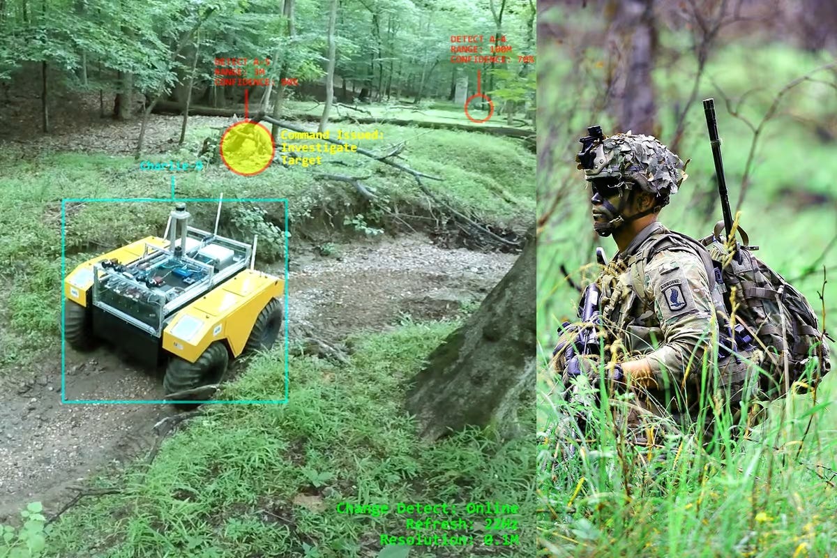
As autonomy and AI processing improve, airborne sensors are increasingly integrated into real-time multi-domain operations, working in tandem with space, cyber, and ground assets to form a seamless intelligence ecosystem.
Aetosky: Turning Imagery into Intelligence
Aetosky’s specialised products integrates all of these data streams - HSI, MSI, SAR, and emerging modalities into a AI-driven analysis system tailored for defense and intelligence operations. At Aetosky, the convergence of advanced sensing technologies with real-time decision intelligence is not merely an aspiration - it is a capability realised through the depth of our engineering and development teams.
Core Aetosky Capabilities:
Spectral Analytics: Automatically processes and interprets hyperspectral and multispectral data for target detection and anomaly analysis.
SAR Analytics: Identifies man-made structures, movement, and infrastructure anomalies even under poor visibility.
Change Detection Engines: Compares imagery over time to flag new construction, troop movement, or repositioning of assets.
Real-Time Alerting and Dashboards: Delivers insights in operationally relevant formats, integrated into military command systems.
Cross-Sensor Fusion: Combines multiple data types into rich, multi-dimensional reports
Managing time-series imagery for environmental change detection, border activity monitoring, and post-conflict damage assessment.
Implementing secure data access controls to manage role-based access across classified and open domains.
Whether managing petabytes of drone ISR over maritime zones or curating multi-decade satellite archives for climate and terrain intelligence, Aetosky empowers government users with clean, structured, and query-ready data pipelines. Aetosky ensures that decision-makers don’t just receive data - they receive insight, intelligence, and strategic advantage.


