
The Future of Defense Intelligence: Aetosky's Multi-INT Advantage
Enhancing Surveillance, Threat Detection, and Strategic Decision-Making with Aetosky’s Advanced Multi-INT Solutions


In modern warfare, speed is dominance. Intelligence is decisive only when it moves faster than the adversary. Superiority is no longer measured by the size of arsenals alone, but by the ability to detect, decide, and act ahead of unfolding events. Victory belongs to those who own the decision cycle - not just once, but continuously. Intelligence must not be a static report; it must be a persistent advantage. Aetosky was built with this reality in mind.

Executive Summary
Warfare has shifted from being platform-centric to data-centric. On today’s battlefields, superiority hinges on who sees, understands, and acts first. Yet, intelligence - the most decisive advantage - often fails to keep pace. Fragmented sources, delayed processing, and incomplete insights leave commanders reactive instead of proactive.
From border security and counterterrorism to maritime awareness and electronic warfare, Aetosky ensures forces are not just informed, but advantaged. It transforms intelligence from fragmented capabilities into a continuous operational edge.
The Modern Intelligence Challenge
The sheer volume, velocity, and variety of defense data have never been greater. GEOINT, SIGINT, HUMINT, OSINT, MASINT - all indispensable, yet traditionally siloed. Intelligence professionals are often forced to operate under a burden of fragmentation, reconciling disparate sources manually, often too late.
The result? Reactive decision-making, limited foresight, and increased risk.
Legacy systems were never designed for this battlespace. Static architectures and stove-piped workflows can no longer support the realities of multi-domain operations. Intelligence arrives out-of-date, leaving decision-makers reacting to yesterday’s threats, instead of shaping today’s battlefield.
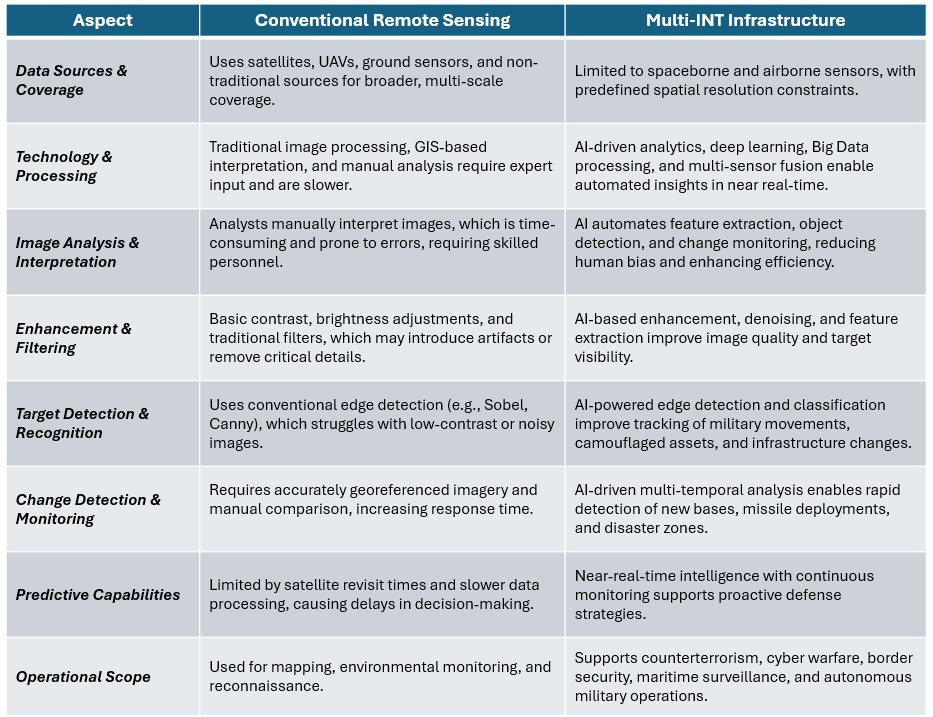
Multi-INT: The Future Beyond Conventional Remote Sensing
While conventional remote sensing provides valuable geospatial insights, Multi-INT infrastructure changes things by integrating multiple data sources, leveraging AI-driven analytics, and enhancing real-time decision-making.
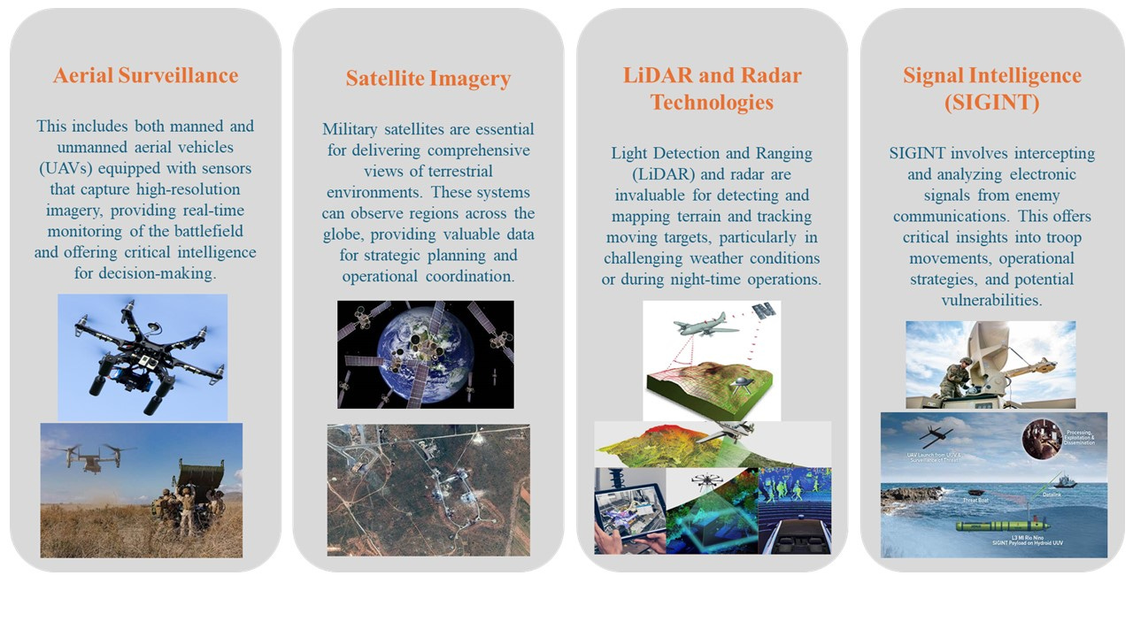
Remote sensing technologies play a crucial role in modern military operations, enabling intelligence gathering, battlefield surveillance, and strategic decision-making. Different technologies such as Aerial Surveillance, Satellite Imagery, LiDAR and Radar Technologies, and Signal Intelligence (SIGINT) are categorized based on their capabilities and applications, enhancing defense operations across land, air, and space domains.
Before AI-driven automation, analyzing aerial and satellite imagery relied heavily on manual interpretation, resulting in slow processing and frequent blind spots, especially against dynamic or concealed targets. Static datasets further limited real-time decision-making in rapidly evolving scenarios. Today, the integration of AI, remote sensing, multi-sensor fusion, and Big Data analytics within Multi-INT workflows has become critical to modern defense operations.
Key Geospatial Advancements and Their Role in Multi-INT
The rapid evolution of Geospatial Technologies has transformed modern defense operations by integrating satellite imaging, AI-driven analytics, real-time mapping, and predictive intelligence. These advancements provide enhanced situational awareness, precise decision-making, and strategic superiority in military applications.
1: AI & Machine Learning for Automated Geospatial Intelligence
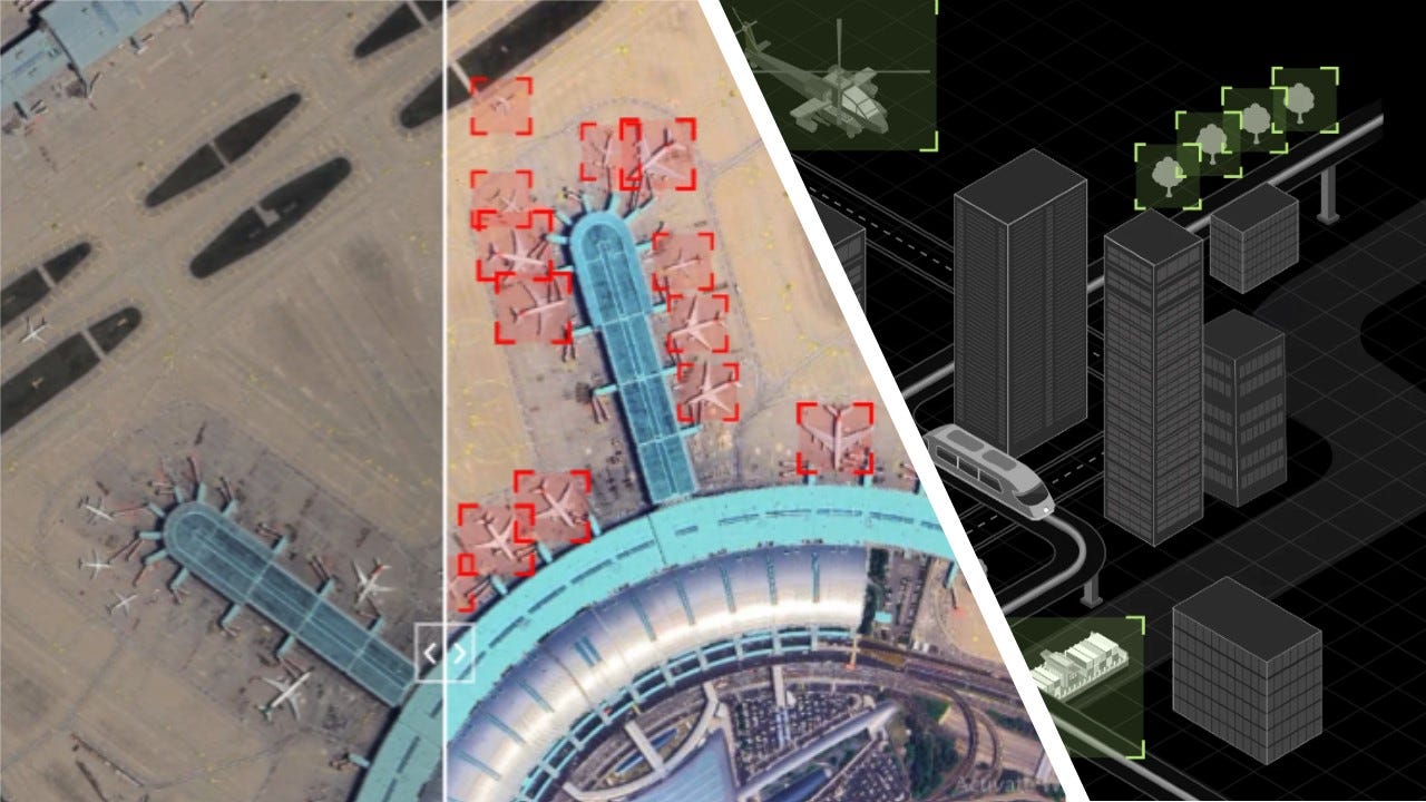
AI-driven models process massive satellite and UAV imagery datasets to detect objects, anomalies, and movement patterns automatically.
Machine Learning (ML) continuously improves geospatial classification, offering enhanced target recognition and battlefield intelligence.
Key advantages:
Automated Threat Detection – AI instantly identifies enemy bases, missile launch sites, and military assets.
Real-Time Intelligence Processing – Reduces manual workload and enables faster decision-making.
Anomaly Detection – AI spots unusual activities, such as hidden infrastructure development or unauthorized border movements.
2. Advancements in Sensor Technology
Modern military surveillance systems rely on cutting-edge multispectral, hyperspectral, LiDAR, infrared, and SAR sensors to enhance detection capabilities.
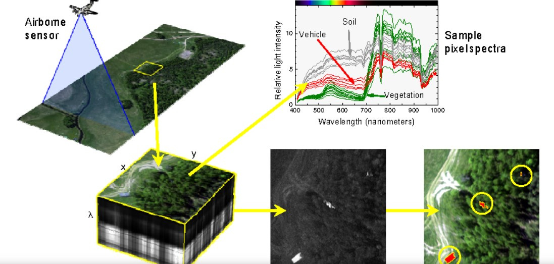
A. High-Resolution & Hyperspectral Imaging for Strategic Surveillance
Hyperspectral sensors detect materials based on their unique spectral signatures, enabling advanced reconnaissance.
High-resolution satellite imaging provides detailed intelligence for battlefield planning.
Key advantages:
Identifies Concealed Military Infrastructure - Detects missile silos, bunkers, and weapons depots.
Monitors Troop Movements - Tracks enemy deployments and supply chain activities.
Chemical & Explosive Detection - Analyzes hyperspectral data to identify hazardous materials and illegal weapons production.
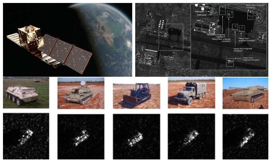
B. Synthetic Aperture Radar (SAR) for 24/7, All-Weather Surveillance
SAR technology provides high-resolution, all-weather, and day-night imaging capabilities, making it an essential tool for military intelligence, surveillance, and reconnaissance (ISR). Unlike optical sensors, SAR can penetrate clouds, smoke, and darkness, ensuring continuous monitoring of critical defense operations.
Key advantages:
Continuous Surveillance - Ensures round-the-clock battlefield monitoring.
Penetrates Clouds & Darkness - Detects threats even in harsh weather or nighttime conditions.
Tracks Moving Objects - Identifies military convoys, naval vessels, and aircraft.
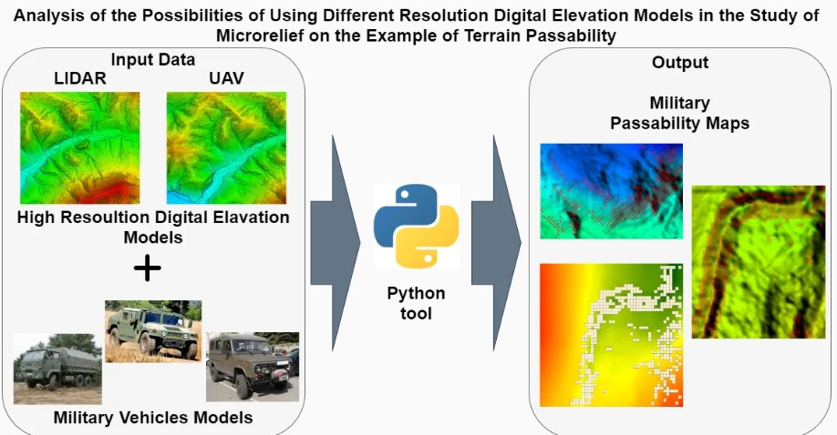
C. 3D Terrain Modeling & Digital Elevation Maps for Mission Planning
LiDAR and photogrammetry generate detailed 3D battlefield maps for military operations.
AI-powered simulation models assist in tactical planning and mission rehearsals
Key advantages:
Flight Path Optimization - Helps UAVs and fighter jets navigate complex terrains.
Helps troops avoid ambush zones and high-risk areas.
Urban Warfare Support - Creates 3D city models for sniper positioning and drone surveillance.
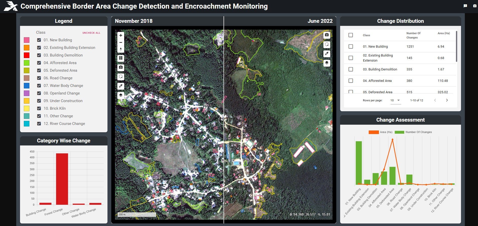
D. Time-Series Image Analysis
Time series analysis plays a crucial role in defense intelligence, surveillance, and reconnaissance (ISR) by analyzing geospatial data over time to detect trends, predict threats, and optimize military operations. When integrated with Artificial Intelligence (AI) and Machine Learning (ML), it provides real-time situational awareness, proactive decision-making, and strategic planning
Key advantages:
AI models compare multi-temporal satellite data to detect infrastructure changes and unusual activity.
Predictive analytics forecast potential security threats based on historical geospatial trends.
Monitors shifting battlefronts and unauthorized military build-ups
Improves border surveillance by detecting new infiltration routes.
Aetosky's Principle: Every Second Counts
Aetosky’s architecture is built on a simple premise: compress the time between observation and action. Our Multi-INT platform integrates space, air, ground, and cyber intelligence into a single, seamless infrastructure - enabling operators to shift from “What happened?” to “What is happening, and what happens next?”
By unifying all intelligence domains into a single AI-powered infrastructure, Aetosky delivers an end-to-end solution. From data ingestion and automated processing to AI-driven analytics and mission deployment, every component is designed to remove latency and human bottlenecks. Deployable on secure cloud, on-premise, or edge environments, Aetosky enables forces to operate with full agility - even in disconnected, contested, or degraded communication scenarios.
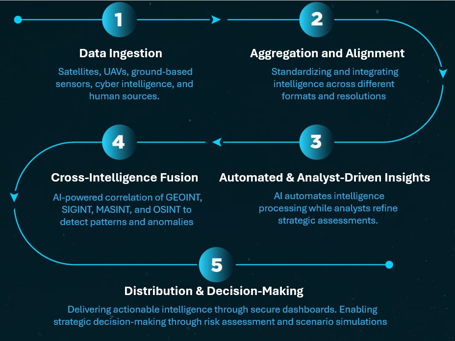
Aetosky’s Multi-INT Process: An Integrated Suite for Defense Intelligence
Aetosky provides a comprehensive, AI-driven platform that streamlines the Multi-Intelligence (Multi-INT) process for defense and government agencies. By integrating various products, Aetosky ensures seamless data ingestion, automated processing, workflow automation, real-time validation, and actionable intelligence dissemination.
A. Seamless Multi-Sensor Ingestion with Aetos Browser
Unified Satellite Tasking: Access private, commercial, and open satellites for on-demand intelligence.
Multi-Source Intelligence Hub: Integrates GEOINT, SIGINT, MASINT, UAVs, IoT sensors, and cyber intelligence into a single collection framework.
B. Analysis-Ready Data Lake with Aetos Cube
Mission-Ready Datasets: Provides pre-processed satellite imagery, weather models, elevation data, and intelligence layers.
Multi-Modal Support: Ingests and harmonizes optical, SAR, hyperspectral, and thermal imagery for surveillance, reconnaissance, and targeting.
C. AI-Driven Processing with Aetos AI
Automated Data Refinement: Enhances imagery quality, aligns data layers, and prepares intelligence for analysis.
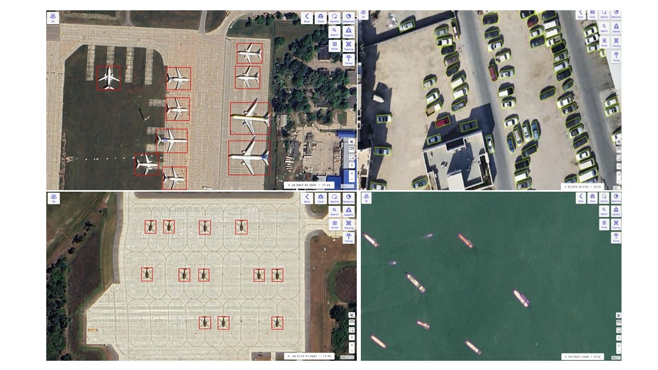
AI for ISR: Rapidly deploys AI models for object detection, change detection, and predictive analytics.
Custom ISR Workflows: Enables dynamic object detection and predictive modeling for border security, maritime surveillance, and counterterrorism.
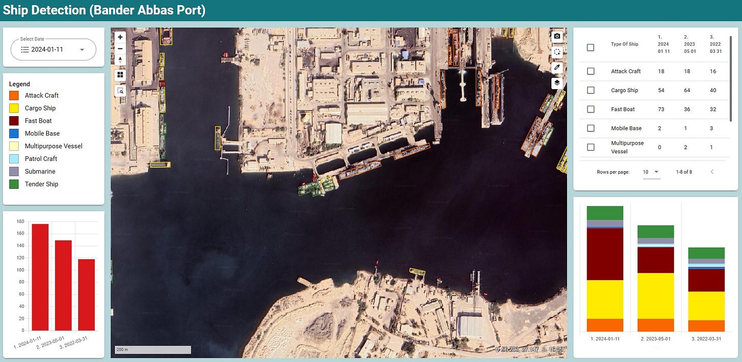
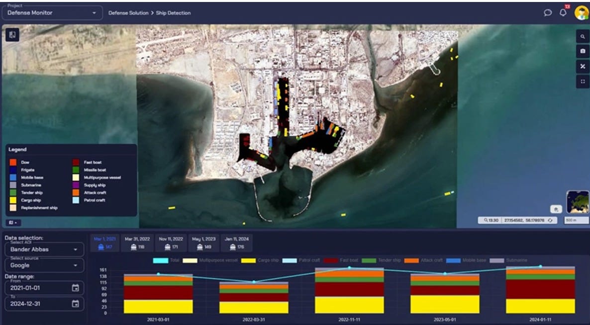
Automated ship detection and classification

D. Autonomous Intelligence Operations with Athena
Automated Intelligence Cycle: Orchestrates data collection, AI model execution, and intelligence generation without manual intervention.
Dynamic Tasking: Automatically selects relevant data, processes imagery, and adapts AI models to mission objectives.
Continuous Intelligence Fusion: Synchronizes real-time Multi-INT streams to enable adaptive, situationally aware decision-making.
Automated Alerts: Triggers actionable alerts for events such as unauthorized construction, vessel movement, or troop deployments.
E. Intelligence Dissemination & Decision-Making with Aetos Canvas
Operational Dashboard: Visualizes intelligence layers, threat maps, and dynamic situational awareness.
Analyst-Centric Tools: Enables drag-and-drop intelligence products for custom threat reports, mission plans, and command briefings.
Conclusion
In today’s battlespace, Geospatial Intelligence (GEOINT) and remote sensing are indispensable, but traditional approaches no longer suffice. Manual processing, fragmented datasets, and static intelligence cycles limit the agility required to outpace modern threats. Adversaries move faster, adapt quicker, and exploit information asymmetry.
Aetosky’s Multi-INT ecosystem closes this gap. By integrating satellite imagery, UAV feeds, sensor networks, and AI-powered analytics into a unified intelligence workflow, Aetosky delivers real-time, decision-grade intelligence at scale. From seamless data ingestion (Aetos Browser) to AI-driven object detection (Aetos AI), automated mission intelligence (Aetos Athena), and operational visualization (Aetos Canvas), every component is designed to compress decision cycles and extend situational advantage.

This is not about simply seeing more. It is about acting faster, smarter, and with precision. Multi-INT fusion turns raw data into predictive foresight, empowering defense forces to shape the battlespace - not just respond to it.
"In modern defense, intelligence is not just about seeing - it’s about acting with precision. Multi-INT fusion turns data into strategic foresight, ensuring nations stay ahead of threats and dominate the battlespace with confidence"
- Dr. Raja Biswas, Senior Research Officer (SRO)
 |
|
 | A guest post by
|