Tracking the Unseen: Oil Spill Detection and Analysis with Remote Sensing
Leveraging Satellite Imagery and Artificial Intelligence to Monitor, Mitigate, and Prevent Marine Pollution
In operational environments where time, accuracy, and preparedness are paramount, oil spills represent not just environmental disruptions but threats to mission continuity, maritime security, and public safety. Whether near naval bases, fuel depots, ports, or offshore infrastructure, undetected oil pollution can lead to cascading impacts. These impacts include operational delays, equipment degradation, and regulatory fallout.
Modern oil spill detection is undergoing a paradigm shift. By fusing multi-source geospatial data with AI/ML-powered analytics, government agencies and defense stakeholders can achieve persistent maritime situational awareness at scale. This article explores how AI-powered geospatial analysis is transforming the detection and response lifecycle for maritime oil spill incidents across strategic domains.
Why Oil Spill Intelligence Matters
Oil spills can occur due to a range of factors: mechanical failure, illegal bilge dumping, offshore drilling accidents, or conflict-related sabotage. In strategic locations, these incidents pose risks to:
Coastal defense infrastructure
Military and commercial navigation routes
Critical logistics and supply chains
Public environmental oversight
Energy and offshore infrastructure
Geospatial Data Sources: Building a Multi-Sensor Architecture
At the core of effective oil spill detection is the fusion of multiple Earth observation datasets. Aetosky’s geospatial intelligence stack integrates:
Synthetic Aperture Radar (SAR): Enables consistent detection regardless of weather or lighting conditions, ideal for night-time or cloudy scenarios.
Multispectral and Hyperspectral Optical Imagery: Useful for distinguishing between oil, algae, and other marine substances, and for assessing thickness and type of oil.
Automatic Identification System (AIS) and Vessel Traffic Data: Correlates spills with potential vessel sources or patterns of illegal discharges.
Oceanographic and Meteorological Layers: Real-time wind, wave, and current data feed into spill drift models for predictive analysis.
A combination of Synthetic Aperture Radar (SAR) and optical imagery are usually used for a comprehensive oil spill analysis, as these two data types offer complementary insights. Optical data - especially from passive sensors like Sentinel-2 and Landsat - serve as a starting point, enabling the detection of oil slicks based on reflected sunlight. In clear atmospheric conditions, RGB bands help distinguish oil from surrounding water based on colour, shape, and texture. Beyond the visible spectrum, Infrared (IR) and Near-Infrared (NIR) bands are particularly valuable, enhancing contrast between oil and water and supporting more accurate delineation of spill boundaries.
Data Pre-Processing in Oil Spill Detection
Pre-processing is a critical step in preparing remotely sensed imagery for accurate oil spill analysis. For optical sensors, the workflow typically involves several key stages: radiometric calibration, atmospheric and geometric correction, image enhancement, and targeted masking. Radiometric calibration compensates for sensor degradation and normalises atmospheric influences, while atmospheric correction ensures accurate retrieval of surface reflectance values. Geometric correction aligns imagery spatially for consistent multi-temporal analysis. Image enhancement techniques are applied to boost the visual contrast of oil slicks, making them more distinguishable. Masking is used to exclude non-relevant areas, improving classification accuracy.
For Synthetic Aperture Radar (SAR) data, the preprocessing pipeline includes radiometric calibration, geocoding, noise filtering, and masking. Calibration ensures consistent backscatter measurements, while geocoding corrects spatial distortions inherent in SAR imaging. Speckle noise, common in radar data, is reduced through filtering to enhance interpretability. Land and shoreline areas are masked out to avoid false positives and focus the analysis on open water, where oil spill detection is most critical.
Operational Use Cases
Coastal Surveillance: Persistent monitoring around high-value military and civil infrastructure (e.g., naval ports, fuel depots) for early threat detection.
Strategic Waterways: Continuous analysis along choke points and shipping lanes to prevent economic and logistic disruption.
Post-Disaster Assessment: Rapid quantification of oil spread following hurricanes, tsunamis, or maritime collisions to guide multi-agency disaster response.
Illegal Discharge Enforcement: Provide evidence-grade data for maritime law enforcement, with vessel movement correlation and time-series verification.
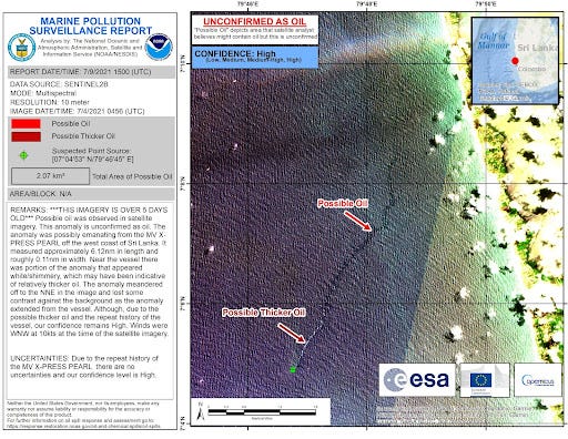
In May 2021, the container ship X-Press Pearl caught fire and ultimately sank after burning for 12 days off the coast of Sri Lanka. The incident resulted in the loss or destruction of all onboard containers, sparking major environmental concerns due to the ship’s fuel and its cargo of hazardous substances. One of the most visible consequences was the rupture of containers carrying low-density polyethylene pellets, which spilled into the ocean and washed up along nearby coastlines, polluting the beaches with microplastics. In response, the U.S. National Oceanic and Atmospheric Administration’s Office of Response and Restoration (OR&R) collaborated with the Sri Lankan government by providing expert technical support. This included the use of satellite imagery from the National Environmental Satellite, Data, and Information Service (NESDIS) to monitor the site for oil leaks or chemical discharges. OR&R also assisted in analysing and interpreting this data to detect any anomalies, playing a critical role in supporting environmental surveillance and informing response efforts.
The Role of AI/ML in Oil Spill Detection and Classification
Estimating the thickness of an oil slick remains a challenge for scientists. A widely used method involves analysing the visual appearance or colour of the slick, then correlating it with standardised thickness categories. These estimations are guided by reference tables and classification schemes, such as those provided by the National Oceanic and Atmospheric Administration (NOAA) through their response and restoration resources. These guidelines help responders approximate oil volume based on visual cues observed in the field or satellite imagery.
Traditional image interpretation methods are labour-intensive and prone to false positives. Aetosky leverages AI/ML algorithms to automate and enhance this process:
1. Anomaly Detection via Deep Learning
Using convolutional neural networks (CNNs), SAR and optical images are analysed for spectral and textural anomalies. These networks are trained on thousands of labelled spill and non-spill instances to reduce false detections.
2. Semantic Segmentation for Spill Extent
Advanced segmentation models delineate the spill’s boundaries with pixel-level accuracy, critical for calculating volume and affected area.
3. Spill Source Attribution
By combining AIS patterns with backtracking algorithms and ML classifiers, likely culprits can be identified, even across multiple jurisdictional zones.
4. Drift and Dispersion Modelling
Reinforcement learning and ensemble simulations forecast the movement of the spill over time. This helps responders prioritise high-risk zones and prepare containment assets.
Preventing Oil Spills
Satellite technology has proven to be a powerful tool for providing rapid, detailed insights into the impact of oil spills. Its ability to detect spills accurately and quickly supports faster, more coordinated response efforts, helping to minimise environmental damage and reduce associated economic costs.
Ongoing advancements in remote sensing aim to enhance the capability of satellites to monitor oil spills, identify pollution sources, and detect small-scale leaks before they develop into major incidents. This proactive approach - commonly referred to as oil spill surveillance, is a vital element of modern spill prevention and disaster management, underscoring the crucial role of satellite systems in safeguarding marine environments.


